
Search Lincoln Street Directory by Address
Lincoln keeps street-level clues in separate systems. The county property record identifies the assessed owner and parcel, the map shows where that parcel sits, and the deed index records transfers and other instruments. A registration lookup can confirm one named voter, while older reverse directories can place a past household at an address. Each answers a narrower question. An owner may receive tax mail elsewhere, a recorded buyer may have moved, and a directory listing is a dated snapshot.
- Confirm the spelling, directional prefix, and suffix in the City Street Directory. Enter a Name, then choose Prefix, Type, Suffix, City, and either Begins With or Equal Match when useful.
- In Orion Property Search, use Advanced Search with Street Name. Add a From and To number range, city, ZIP, neighborhood, or Active status to narrow the run.
- Open the address in the city-county GIS viewer and compare the parcel with the adjoining lots. Note the Parcel ID, legal lot or subdivision, and any boundary layer that affects the block.
- Use the PID or legal description to check the recorder index for deeds and liens. Search the named party again when following the transfer sequence backward.
- For a dated household clue, use Lincoln City Libraries' reverse or criss-cross directory holdings. A criss-cross directory is arranged by address rather than surname.
Numbered Lincoln streets need their ordinal endings. The City Street Directory requires at least two letters for Begins With, and a numbered name must use an ending such as ST, ND, RD, or TH. That small formatting check prevents a failed street search before the property work begins.
Lincoln Street Names and Suffixes
A modern label may not match an older source word for word. Lincoln's addressing system uses directional prefixes and abbreviated types, while historic collections can preserve an earlier form. University Place joined Lincoln after a 1926 agreement, and its street names and addresses changed in 1927. When an older directory or deed seems to skip an address, compare the street-name key, the legal lot, historic city limits, and both the old and current name before deciding the trail ends.
The City has an annexation record and planning resource for checking the wider municipal history. For a current street result, the official directory is the safer first stop because it separates prefix, name, type, suffix, and city fields. That structure matters most on a long avenue, a numbered street, or a street that crosses a changing jurisdiction.
Note: A street label establishes how a road is named, not who receives mail or lives at every numbered address.
Lincoln Parcel Search Fields
Orion's quick search accepts owner, address, or PID fragments, but it searches owner names, street names, and legal descriptions together. A search for “Pointe Cir,” for example, can surface a legal-description match that is not actually on that street. For a Lincoln street directory result, Advanced Search is the better route because Street Name and the number range can be set directly. Owner entries use last name, first name. A PID may be entered without dashes or in the county's dashed form, such as 10-26-225-002-000.
| Orion field | Use for a street search |
|---|---|
| Street Number From / To | Sets a frontage range when used with Street Name. |
| Street Name | Returns properties on that street in Advanced Search; use the abbreviated type expected by the portal. |
| City and ZIP Code | Reduce a result set where the same name reaches beyond one area. |
| Neighborhood | Limits results to a named neighborhood when that is known. |
| Property Status | Lets the search be limited to Active, Inactive, or All records. |
| Property ID | Connects a known parcel to its detail card without relying on the street wording. |
The Lancaster County assessor search shows the public interface used for these fields.
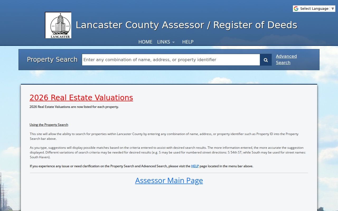
The Advanced Search link is important because it keeps a whole-street query from being confused with a similar phrase inside a legal description.
Lincoln Street Parcels on GIS
The Lincoln and Lancaster County GIS Viewer supplies the visual check after an Orion range search. Turn on Street Names or Street Labels, Addresses or Address Labels, Parcel_Info, and parcel lines. Then click the target, pan along the road, and click each adjoining polygon. The map can also show subdivisions and condominiums, property sales, zoning, floodplain, Lincoln city limits, historic city limits, and the extraterritorial jurisdiction.
Aerial imagery and parcel lines can expose a second lot, an alley, a shared drive, or a condominium arrangement that a simple street-number sequence hides. Use the selected PID to return to the assessor card. The map's geometry helps locate a parcel, but it is not the authoritative ownership record. The assessor card is where owner, situs, mailing, value, status, exemption, sales, and legal-description fields belong.
Lincoln Address Permits and Plans
Property records do not provide a complete physical history of a street. Accela Citizen Access lets a registered user search an existing permit by address, parcel, or permit number. An entered address can supply the parcel number and owner name. PATS tracks planning applications by street address or PID, which can add a subdivision, zoning, annexation, or planning context to a block.
Lincoln's legacy occupancy search covers May 1, 1999 through January 18, 2013. Later permits belong in Accela. Permit, planning, and occupancy entries identify an address-related event or applicant relationship at a point in time. They should not be turned into a claim about every person connected with the property.
For a much older physical clue, the Local History Center provides access to Lincoln material that includes Sanborn maps. Those maps date building features and lot use, rather than residents.
Lincoln Records Along a Street
These sources form an address trail, but their scope differs. The PID ties the property card to a parcel and often to a permit or planning search. A legal description ties the same land to a plat and recorded instrument. A street name gets the researcher to the right frontage, then the parcel and instrument number keep the record trail precise.
| Record route | Address clue | Custodian | Access |
|---|---|---|---|
| Assessor parcel card | Owner, situs, mailing address, PID, value, exemption, and legal description | Lancaster Assessor/Register of Deeds | Orion and counter records |
| GIS parcel layers | Parcel location, adjoining lots, labels, limits, sales, zoning, and flood layers | City of Lincoln and Lancaster County GIS | Public viewer |
| Recorded index | Grantor, grantee, instrument, date, type, book or page, and legal description | Lancaster Register of Deeds | Tyler index; images have access limits |
| Permit and planning records | Address, PID, permit or application, owner or applicant, inspections | Lincoln Building and Safety / Planning | Accela, PATS, or request |
| Voter and directory sources | One named registration or a dated address listing | Election Commission / Local History Center | Lookup or lawful request; library access |
A situs address is the physical property address. A tax mailing address is where the statement is sent. The two can match, but a mailing address is only a contact clue, not evidence of occupancy. Follow the legal description, not just a similar street name, when moving from the property roll into the recorded index.
Lincoln Deeds by Street
Tyler's Lancaster County document index is the deed-chain step after the parcel has been identified. Search a current owner as a grantee or grantor, narrow by date or document type, and retain the instrument number, recording date, legal description, and book or page reference. A recorded sale confirms a transaction, not a current address or household.
Insider tip. June 19, 1987 is the decisive cutoff for Lancaster's electronic index. Earlier records use handwritten index books, book and page archives, or office microfilm rather than a complete modern name search.
The recorder's search help supports grantor, grantee, or either-party searching, plus date range, document type, and instrument controls. Exact party searching uses last name first, Advanced mode is order-independent, and an asterisk is a wildcard. Instrument numbers must include a four-digit year. These controls can make an old owner name easier to test without assuming that a hit identifies the current resident.
The public Tyler document-index entry identifies the online cutoff and access path.
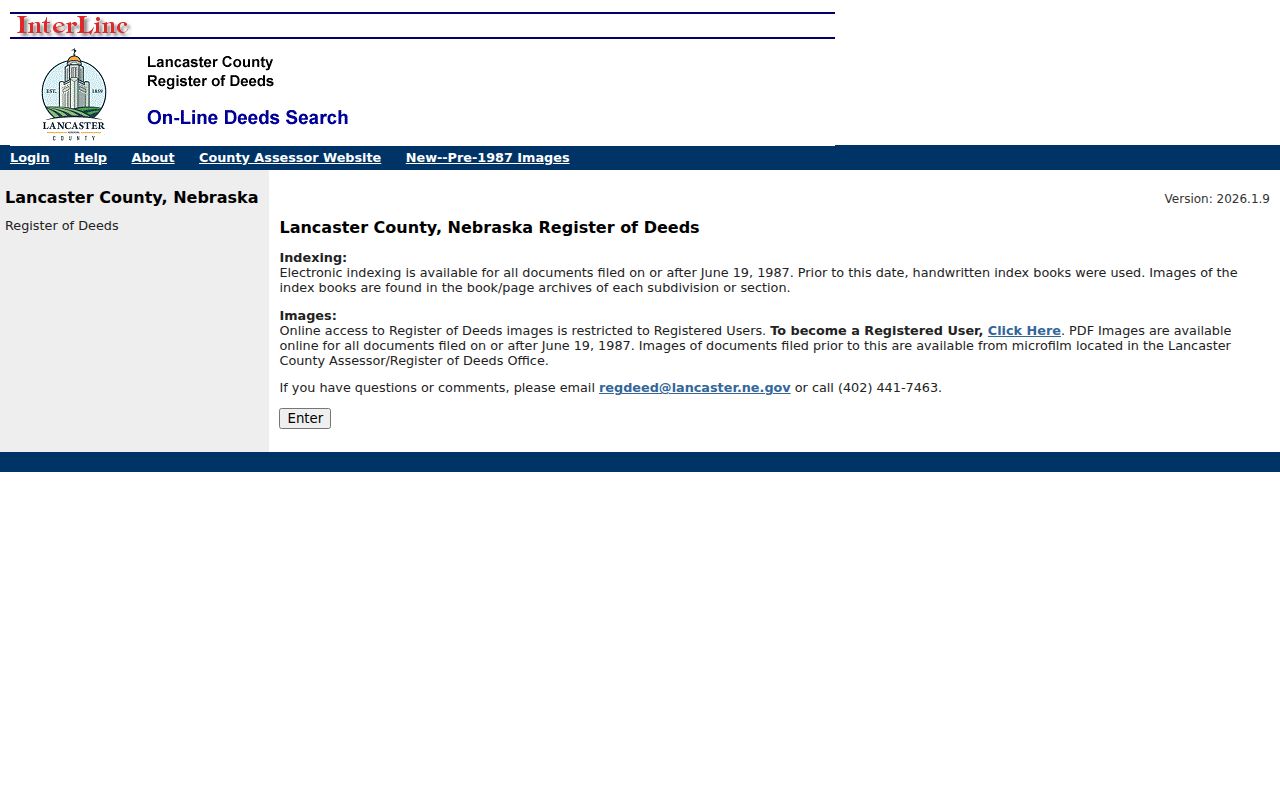
Use the index reference to request or inspect the correct document, then compare the legal description with the assessor parcel before treating it as part of the same street trail.
The Tyler name and instrument help shows the available party, date, match-mode, and wildcard controls.
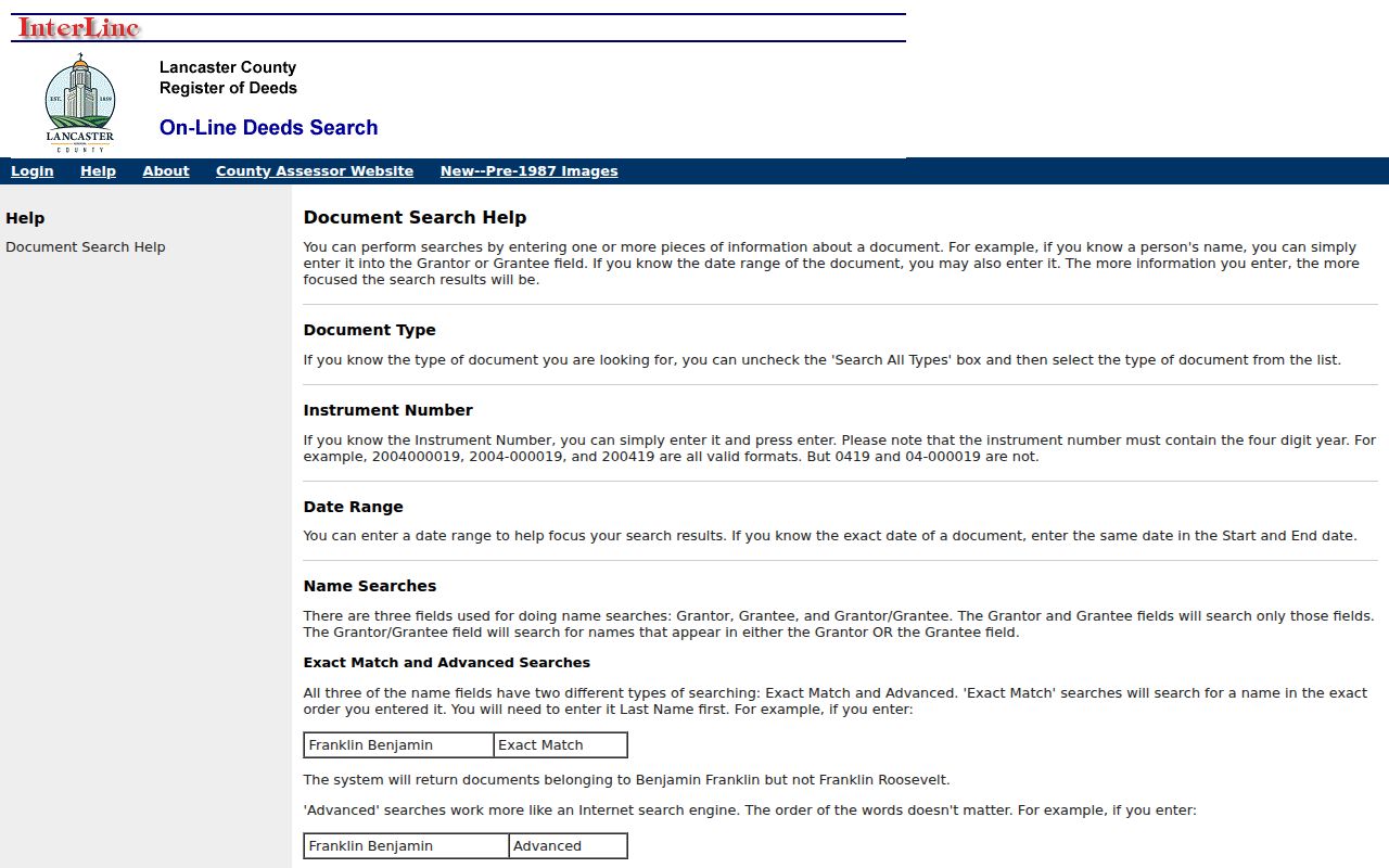
The help screen is a useful reminder that an instrument search and a person-at-address search are different tasks.
Lincoln Voter Records by Street
VoterView takes a first name, last name, and Lancaster County. It can confirm a named registration and polling information, but it does not browse a street or produce a block roster. For a fuller lawful list, the Lancaster Election Commission voter-list process requires the applicable request and statutory-purpose oath. Private and confidential records are withheld.
Myth: a public voter register is not an unrestricted list of every person on a street. Nebraska's access limits in §§32-329 through 32-331 restrict use of distributed lists. They cannot be posted online or used commercially, and a registration result does not establish who lives in every unit at an address.
A person who only needs registration confirmation should use VoterView for that named person. The lawful-request route is more formal and has purpose, handling, and copying limits. Treat the result as an election record, not a general directory.
Lincoln Historic Street Addresses
Older address work requires tools built for time as well as location. The Bennett Martin Local History Center holds Lincoln city directories beginning in 1873, along with newspapers, yearbooks, genealogy material, and map resources. The reverse section of a directory can show the household listed at a particular address in that edition. It is a lead to verify, not proof of a present-day resident.
- Parcel
- A defined piece of land in the county assessment system, normally identified by a PID.
- Situs address
- The physical location of the property, distinct from the address used for tax mail.
- Plat
- A recorded map that connects a subdivision's lots and blocks to the land description.
- Criss-cross directory
- An address-arranged directory used to find a listed name from a street and number.
For an old street that changed at annexation, pair the directory entry with the lot, block, plat, and the GIS historic-city-limits layer. That combination is more reliable than guessing from a familiar modern street name alone.
Note: A historical directory records what its publisher printed for that year, including omissions and abbreviations.
Limits of Lincoln Street Directory
A street directory cannot identify every household. Public parcel files emphasize land and tax administration, so a mapped owner or tax-mail recipient may not be the person at the situs. Rental occupants, other household members, utility and delivery customers, full DMV addresses, protected voter information, Address Confidentiality Program participants, sealed matters, and nonpublic police records are not a public by-street list.
Lincoln's records are useful for personal history, estate questions, civic curiosity, and checking a parcel trail. They require careful reading because names repeat, addresses change, and records have distinct legal limits. Correct a property error with the Assessor/Register of Deeds and direct voter questions to the Election Commission.
Lawful use. Use Lincoln address records only for a lawful personal purpose. Do not use them to stalk, harass, threaten, intimidate, or harm anyone; Nebraska law addresses that conduct.